

Route 90 Road trip - טיול בכביש 90 - Around Jericho
- Mike Levitt

- Mar 13, 2017
- 8 min read


Right at the start of the northern section of route 90, the section known as Derech Gandi (Gandhi's Road) after the assassinated Minister of Tourism, Rehavam Ze’evi, just south east of Jericho, is Kibbutz Beit HaArava (בית הערבה) (see map here). But originally the kibbutz was 5 km to the east of its current site. Beit HaArava was established on this site in 1939 by European members of Zionist youth movements who had fled Nazi Germany to Mandatory Palestine via Youth Aliyah, and named after the biblical village of the same name (Joshua 18:22). On 20 May 1948, after a failure to reach an agreement with Transjordan's King Abdullah, Beit HaArava was evacuated and the Jordanians destroyed it. In 1980, Beit HaArava was re-established as a Nahal outpost, and it became a civilian community in 1986. In 2000, the village moved to its current site.

The original site of Beit HaArava.
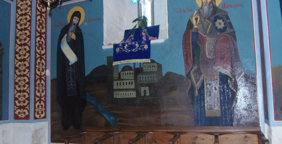
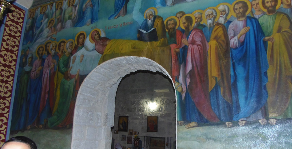
Just north of Beit HaArava is St Gerasimo’s monastery (המנזר של גרסימוס, Deir Hajla), a Greek Orthodox monastery with beautiful icons and gardens. It was founded in 455 CE by Abbot Gerassimos of the Jordan, and is one of the earliest monasteries. Gerassimos was a monk from Lycia (Anatolia in modern Turkey), who headed an ascetic community of 70 monks in the area east of Jericho, and is regarded as one of the second generation leaders of the Judean desert hermits to follow Euthymius and Chariton. Gerassimos attended the Fourth Ecumenical Synod at Chalcedon in 451 CE, a key moment in the development of Christianity which caused a split in Christian Orthodoxy. Gerassimos was initially against the decisions of the council, but later supported them. Gerassimos died in 475 but, since the Byzantine monastery was completely destroyed during the Persian conquest of 614 CE, his burial place is unknown. His saint’s day is celebrated on 4th March.

St Gerasimo’s monastery
Gerassimos met a lion near the river Jordan, roaring in pain because of a thorn was stuck in its paw. After removing the thorn the lion became tamed and joined the community. This encounter is a central theme in the paintings and sculptures in the monastery, and the lion is often illustrated with a donkey and camel.

Gilded lion at the entrance to St Gerasimo’s monastery
The monastery’s name in Greek – Mar Yohanna Hajla – and in Arabic – Deir Hijla ("monastery of Hijla") – preserves the name of the nearby Biblical city of Beth-Hogla (now being resettled). Saint Gerasimo’s monastery was one of fifteen monasteries located in the area in Byzantine times. The original Byzantine monastery was built in the form of a Laura - a cluster of caves or cells for hermits with a common centre, which is still located 1 km to the east of the monastery, on the northern face of a cliff, but it was far too hot to walk there.

The original monastery, the Laura of Saint Gerasimo
When the Persians destroyed the Byzantine monastery in 614 CE, they massacred the monks, whose remains were kept in the crypt on the lower floor; today they are displayed in the anteroom to the church on the first floor. The monastery structure was repaired several times during the Arab period (7th-12th centuries CE), but there are few remains from the Byzantine structure. It was the Crusaders who rebuilt the monastery in the 13th century, and most of the current structure dates to this time, although the periodic earthquakes, including the severe earthquake of 1837, made necessary frequent rebuilding.
When the British soldier-surveyor and explorer, Claude Conder, went there in the 1870s, he found one Greek monk sent down from Mar Saba to guard the ruins. By 1882 a new monastery was being built, he noted, and the monks had “deliberately scraped off all the frescoes” he had seen years before. The site of the Monastery was examined in the PEF survey (1866-1877) by Wilson, Conder and Kitchener, which describes it as follows:
“An important ruin of a mediaeval monastery. The ruin included a large chapel, a second smaller to the south, and a third in the vaults below. The whole is surrounded by a wall, which remains almost perfect on three sides, but is destroyed on the north. [...]This monastery is sometimes known as Mar Yohanna Hajlah —'St John of Hajlah.' In the sixteenth century it was inhabited by monks of the Order of St Basil, and was known to the Latins as the monastery of St Jerome as early as the fifteenth. In the fourteenth century the place is called Bet Agla by Marino Sanuto. Its earlier history is not known. It may perhaps be the monastery of Calamon, which existed in this neighbourhood in the twelfth century.”
Today the monastery has been restored and the Greek Orthodox Church is building a giant amphitheatre to overlook the Jordan River from the monastery, called Alexander the Great Macedonian Theater. Below is a slide show of pictures inside and outside the monastery.


Just north of St Gerasimo's monastery, a road leads east from Route 90, through minefields laid in a surreal landscape of abandoned churches and monasteries, to the Jordan river. This is Qasr al-Yahud (“The Jews' Castle” or “Palace”), the site which in the Christian tradition is associated with Jesus' baptism by John the Baptist (Matthew 3: 13-17). It has been revered as such from at least the fourth century CE. There are many monasteries and churches in the area testifying to the long religious tradition at Qasr al Yahud, though deserted and inaccessible due to mines laid in 1967. The site was under Jordanian control from 1948 until the Six-Day War of 1967, when Israel captured the West Bank from Jordan. Like many areas along the Israel-Jordan border, it was a site of fighting.
Although a renovated pilgrim site at the Jordan river reopened in 2011, the deserted churches may only be viewed from the access road. In fact the restoration project was approved before the 2000 millennium celebrations but was delayed due to the Second Intifada and flooding in the region in 2003. Today plans exists to clear the minefields and restore the churches, under the auspices of the Ministry of Defence and the British de-mining charity, the Halo Trust.
The site is in effect the Israeli side of Al-Maghtas, a similar site on the Jordanian side of the river Jordan, also known as “Bethany Beyond the Jordan,” though the Arabic name has traditionally been applied to the sites on both sides of the river. The place is recorded in the 4th century Madaba map as “The baptism of St John.” In Jewish tradition the crossing of the Jordan by the Children of Israel under Joshua (Joshua 3) must also have taken place in this general area. It is also associated with the site where Elijah handed over the prophecy to Elisha and rose to heaven on a fiery chariot (2 Kings 11).

The approach to Qasr al-Yehud between minefields; in the distance are new churches being erected on the Jordanian side
You can see some of the abandoned churches and monasteries, along with the new baptismal site which is frequented by large numbers of pilgrims, in the slide show below.


A little north of Jericho is a set of ruins we frequently noticed, immediately to the east of route 90, which is unmarked and took some identifying! A close reading of Josephus (Antiquities XVII: 340) suggested it might be the city of Archelaïs (ארכלאיס), the site being known by the Arabs as Khirbet el-Beiyudat, and further research confirmed this. It was founded by Herod the Great's son Archelaus to house workers for his date plantation in the Jericho area. Archelaus was hated by his Jewish subjects no less than his father, and he was no less cruel. When protestors threw stones at Archelaus’s soldiers on one Passover, Archelaus responded by killing 3,000 of his countrymen in the Temple.: “They were slain like sacrifices themselves… till the Temple was full of dead bodies,” according to Josephus, who relates how the event was described to Augustus in Rome.
Near the road, a mound rises to a height of 5 metres and below it a broad plain extends to the east. On the mound is a monumental tower, which covers an area of 300 square metres and remains to a height of 9 metres. The foundations of the tower are built of fieldstones roughly dressed on their outer faces. T he walls of the tower are 1.2 metres wide and consist of two masonry faces with a core of small stones bound with mortar. The outer face is constructed of sandstone ashlars laid as alternating headers and stretchers; the inner face consists of soft local limestone fortified with marl. A coating of thin white plaster bearing traces of red paint is preserved on some of the stones on the outer face. The tower is divided into long, narrow rooms and square-shaped rooms.

The ruins of Archelaïs: a monumental tower, which covers an area of 300 square metres and remains to a height of 9 metres. Perhaps the remains of the tower shown in the Madaba map (see below).
In June-July 1986, Hananya Hizmi directed a rescue excavation at Khirbet el-Beiyudat, organised by the Judea and Samaria Region Headquarters Archaeological Office. Most of the remains uncovered dated to the Early Roman (Herodian) period, with a small number belonging to the Late Roman and Byzantine periods. The Herodian period remains include a monumental tower built of ashlar masonry, a luxurious residence, a way station, and an aqueduct (Hizmi, H (2008), Archelaus Builds Archelais, Biblical Archaeology Review 34.4). Like his father Herod, Archelaus had a passion for building. The massive mansion he constructed at his namesake city was over 3,000 square feet. Visitors entered through a columned portico into a large central courtyard. Finds indicated that the courtyard was decorated according to Greek fashion with Doric column capitals, yet its mikveh also confirmed the ethnicity of the inhabitants.
Josephus describes Archelaïs as a centre of agricultural wealth, and it was still flourishing in the Byzantine period. Despite its lack of Biblical associations, Archelaïs’ importance as a road station warranted its inclusion on the Madaba mosaic map (with its Greek name, APXEΛAIς), where it is represented with a towered entrance flanked by two further towers. In Christian times, the town became a bishopric.

Detail of the Madeba map, showing Archelaïs.
In the Roman period an army camp was erected on the site, and in the Byzantine period a church was built, with a coloured mosaic pavement and five inscriptions in Greek (Hizmi, H (1990), The Byzantine Church at Khirbet el-Beiyudat, Christian Archaeology in the Holy Land). The church remains lay undisturbed for centuries until the mosaic floor was accidentally cut in 1986 by two narrow trenches, in the process of laying telephone lines. The scars of those trenches can be seen in the photo of the excavated church (below), which is now partially covered over with earth. Hizmi uncovered the floors and initial wall courses of a complete basilica church with two side rooms on the south side and a raised bema, all of the floor surfaces covered with geometric -mosaic patterns. Inscriptions in the mosaic floor indicate that it was paved during the 6th century CE.


Khirbet al Beiyudat has also been tentatively identified as Seraiah or Sraya, north of Jericho, where Eusebius and Jerome mention the tower "Magdal Sena’a (Onomasticon, 154, 16, 17), in which case this might be the identity of the monumental tower. Below is a slide show of the site today.


Comments