

The PEF Rock
- Mike Levitt

- Aug 23, 2022
- 5 min read
18 June 2021

Not many people travelling along Route 90—even if they are in no rush and enjoying the incredible scenery of the Judaean desert on one side, and the Dead Sea and Jordan on the other—notice the PEF Rock. It is easily missed and, to be honest, there is not much to be seen.
But if you consider that there had never been a road alongside the Dead Sea's western shore until after 1967, and that the few ancient settlements near its banks could only access each other by boat, and that the PEF Rock dates from 1900-1917, then it is, in its own unremarkable way, remarkable!
So what on earth is the PEF Rock or, in Hebrew, "P.E.F. סלע"?
Between the years 1900 and 1913, and again in 1917, the Palestine Exploration Fund (PEF) measured the water level of the Dead Sea regularly, and established a datum or reference level by marking a protruding rock, near to the springs of Einot Tsukim (Ein Feshkha), with red paint—still visible today, although retouched in black when we stopped to look—exactly fifty centimetres above the surface of the water. The initials 'PEF' are coarsely engraved on the rock.


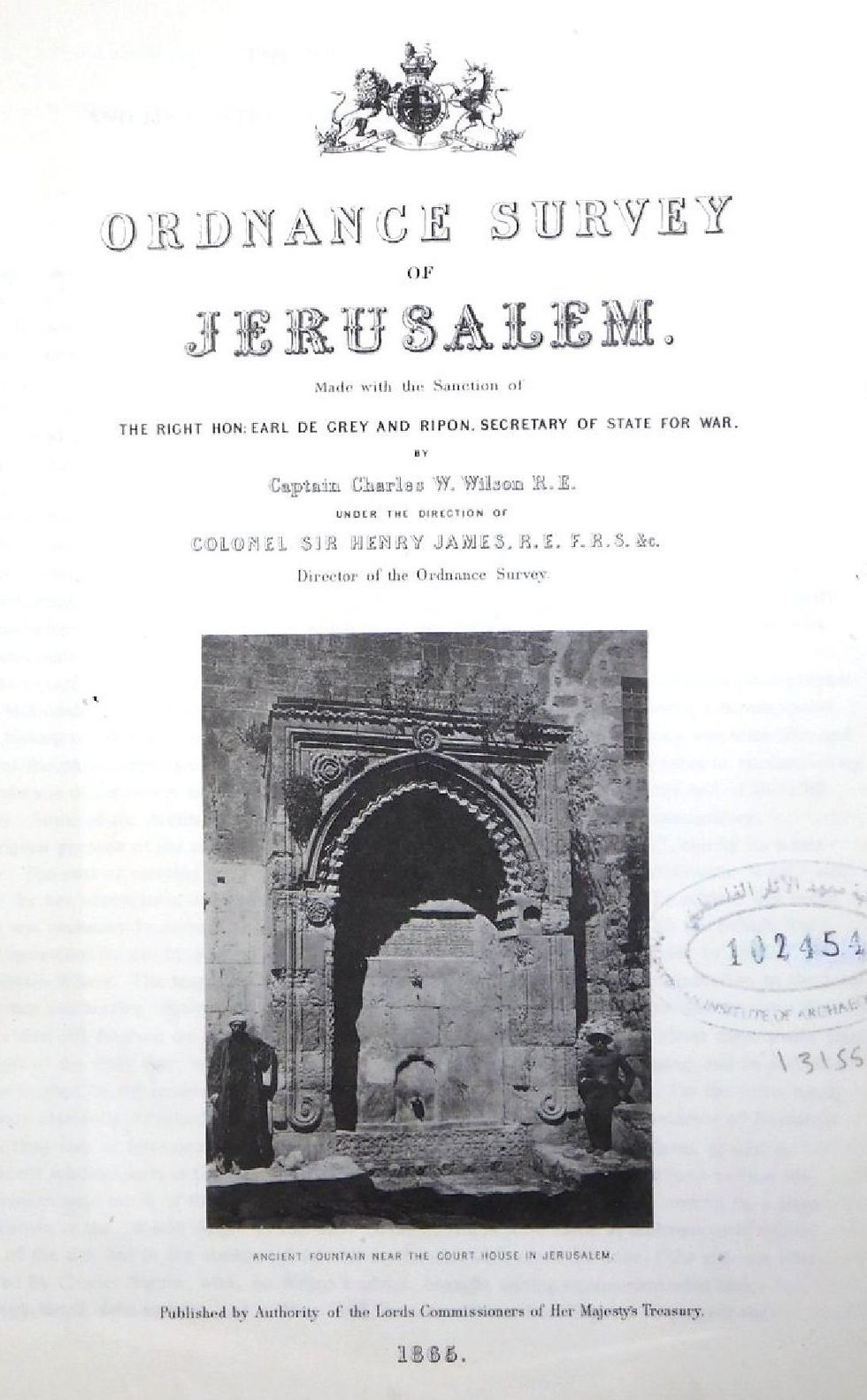
The Palestine Exploration Fund was founded in London, shortly after the completion of the Ordnance Survey of Jerusalem of 1864–65. This survey was the first scientific mapping of Jerusalem, and the first Ordnance Survey to take place outside the United Kingdom. It was undertaken by Charles William Wilson, a 28-year-old, Liverpool-born officer in the Royal Engineers corps of the British Army, after whom is named the eponymous Wilson's Arch at the Western Wall. Wilson, together with a team of six Royal Engineers, began their work on 3 October 1864, and completed it on 16 June 1865, publishing their report on 29 March 1866. The Jerusalem Post did not exaggerate when, in 2016, they commented that Wilson's efforts "served as the basis for all future Jerusalem research".
The Biblical archaeologists and clergymen who had financially supported the Ordnance Survey founded the Palestine Exploration Fund on 22 June 1865, with initial funding of £300, "for the purpose of investigating the Archaeology, Geography, manners, customs and culture, Geology and Natural History of the Holy Land". The PEF remains the oldest known organization in the world created specifically for the study of the Levant region, then known as Palestine. It is still in existence today.
The first meeting of the Society of the Palestine Exploration Fund took place in the Jerusalem Chamber of Westminster Abbey, and William Thomson, the Archbishop of York, read out the original prospectus:
"Our object is strictly an inductive inquiry. We are not to be a religious society; we are not about to launch controversy; we are about to apply the rules of science, which are so well understood by us in our branches, to an investigation into the facts concerning the Holy Land. No country should be of so much interest to us as that in which the documents of our Faith were written, and the momentous events they describe enacted. At the same time no country more urgently requires illustration ... Even to a casual traveller in the Holy Land the Bible becomes, in its form, and therefore to some extent in its substance, a new book. Much would be gained by ...bringing to light the remains of so many races and generations which must lie concealed under the accumulation of rubbish and ruins on which those villages stand ..."
Amongst the huge amount of work undertaken by the PEF since its inception, perhaps its seminal work—still the cornerstone of archaeology in Israel today—is the PEF Survey of Palestine. The Survey started with Western Palestine, but was intended to include at a later date Eastern Palestine (Trans-Jordan), Southern Palestine (Negev and Sinai), and Northern Palestine (Lebanon and Syria).

The Survey of Western Palestine covered 6000 square miles and included a set of 26 highly detailed maps, at a scale of 1:63,360, the most detailed and accurate map of Palestine published in the 19th century. The majority of the work of the survey was carried out by the Royal Engineers. The first fully scientific mapping of Palestine, the survey was conducted with support of the British War Office for complex political reasons. With Charles Wilson, already mentioned above, a member of PEF's Executive Committee and acting as liaison, different governmental bodies, particularly the War Office, were involved in all stages of the Survey of Western Palestine. Alongside the geographic aspects of the survey, the Conder and Kitchener collected for the PEF thousands of place names with the objective of identifying Biblical, Talmudic, early Christian and Crusader locations, from which EH Palmer produced a volume which includes their collected Arabic nomenclature alongside English place names as part of the published survey (1881).

In addition to the extensive maps, the Survey also included 50 plates supplemented by nine volumes of extensive writings on all aspects of Palestine. An Introductory Volume was produced by by Trelawney Saunders (1881). Lieutenant Claude Reignier Conder, English soldier, explorer and antiquarian, and Lieutenant Horatio Herbert Kitchener, later later Field Marshal Lord Kitchener, and Secretary of State for War at the beginning of World War I, produced three copious memoirs on the topography, orography, hydrography and archaeology of Galilee (1881), Samaria (1882) and Judea (1883). These monumental volumes included detailed accounts of every hill range, stream, spring, village, town, ruin, and large building in Palestine, also noting every statement as to topography gathered by Conder from Jewish, Samaritan, Greek, Latin, and Norman French sources, with additional contributions from Josephus, the Bible, Pliny, Strabo, the Rabbinical writers, the Samaritan chroniclers, the Onomasticon, the early Christian pilgrims, and the Crusading and Arab chronicles.
A volume on Jerusalem was produced (1884) by Charles Warren, an officer in the Royal Engineers and one of the earliest European archaeologists of the Holy Land, and particularly of the Temple Mount, for whom Warren's Gate, in the Western Wall beyond Wilson's arch, and Warren's Shaft, next to the Gihon Spring, are named, and Claude Conder. Henry Baker Tristram FRS, the English clergyman, Bible scholar, traveller and ornithologist, contributed a volume on flora and fauna (1885), and Edward Hull FRS, the Irish geologist and stratigrapher, one on geology (1886). Special Papers on topography, archaeology, manners and customs were published as a separate volume, together with a complete General Index by Henry C. Stewardson (1888).
The other surveys were never begun, apart from the Survey of Eastern Palestine, of which only one volume was published, covering ‘Adwân—part of Trans-Jordan (1881-1882). Even this was abandoned, with the British Conquest of Egypt of 1882 representing a shift in priority for the government. The fact that the survey did not continue without government support tends to indicate that it was never to have been an independent survey of the PEF.


Left: Charles Warren [Source: carbon print portrait by Herbert Rose Barraud of London, Public Domain]
Right: Reverend Dr Henry Baker Tristram FRS [Source unknown, Ibis Jubilee supplement 1908, Public Domain]

So now you know what is the PEF Rock! Though perhaps hardly a tourist attraction, it is a marker of historic interest, and a somewhat alarming memorial to the rapid disappearance of the Dead Sea since what was, a century ago, a mere half-metre above the surface of the Dead Sea is today several metres above the road, which is itself about forty metres above the Dead Sea!
Comments